A cool design: how to conceive future cities by controlling the Urban Heat Island effect
We live in times when cities must reinvent themselves. The impact of climate change is more and more visible, as in France where the five hottest years since 1900 have occurred during the last decade. In this context, a good environmental design based on multidisciplinary urban engineering competences is crucial for the future development of our cities. More specifically, urban physics must be at the center of the design choices in order to improve urban living. Resilience facing climate change should be conducted also by controlling the Urban Heat Island (UHI) effect.
Let’s start from the fundamentals: cities modify the natural environment through their materials, forms, and human activities. These local transformations bring about modifications in humidity, wind, temperature, and even precipitation compared to the nearby countryside: cities create their own urban climate.
The effect that we can feel the most clearly is the difference of temperature in the inner city core with respect to the surrounding countryside. British meteorologist Luke Howard in his book The climate of London (1833) showed for the first time through a multi-year measurement campaign this difference in temperatures between urban and rural environments, highlighting that this phenomenon is more pronounced during winter and at night.
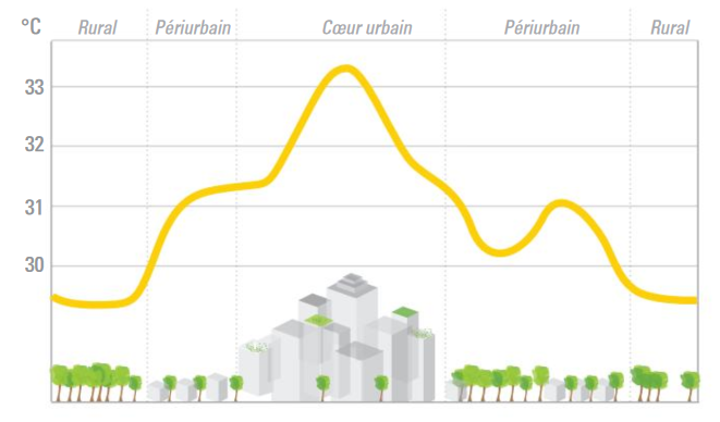
Urban heat island effect: temperature profile of a typical summer day. Source : LBNL; Elaboration: Elioth
This phenomenon called Urban Heat Island (UHI) has numerous causes, but also numerous consequences, particularly during summer heatwaves: decrease of outdoor comfort, increase of building cooling demand and pollution, health-related issues. As if that were not enough, climate change increases the negative consequences of UHI. The abnormally high mortality rate during the 2003 summer heatwave was indeed much more pronounced in cities. What will happen if these phenomena become a usual occurrence?
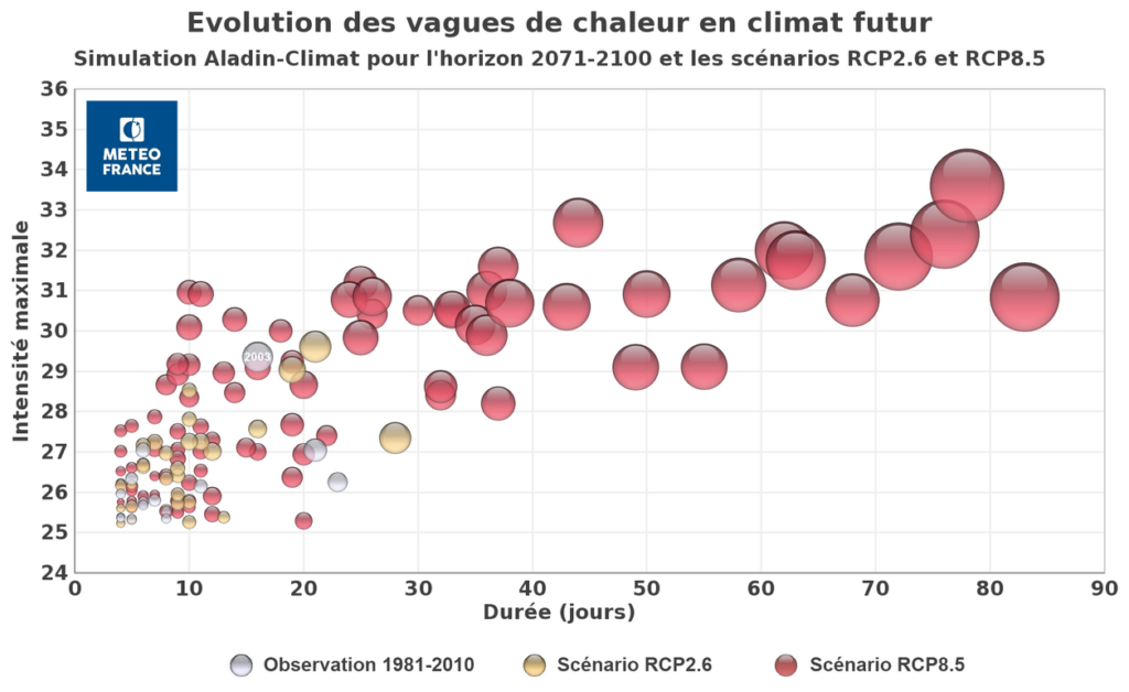
Evolution of heat waves under future climate: Aladin-Climat simulation for the 2071-2100 timeframe and RCP2.6 and RCP8.5 scenarios. Source: MéteoFrance
The causes
Most of the attention to UHI is focused on materials absorbing heat and the absence of vegetation in urban environments. Indeed, our cities are mostly composed of mineralized surfaces, which trap the heat during the day and then release it at night. Darker colors which are typical of asphalt, concrete, and some stones intensify this phenomenon by decreasing the part of solar radiation that is reflected into the atmosphere. In addition, these surfaces often take the place of vegetated surfaces, which would allow the temperature to be regulated according to the day-night rhythm. In more technical terms, we can say that the albedo of materials used in cities is lower than the one that is naturally present in a non-urbanized territory.
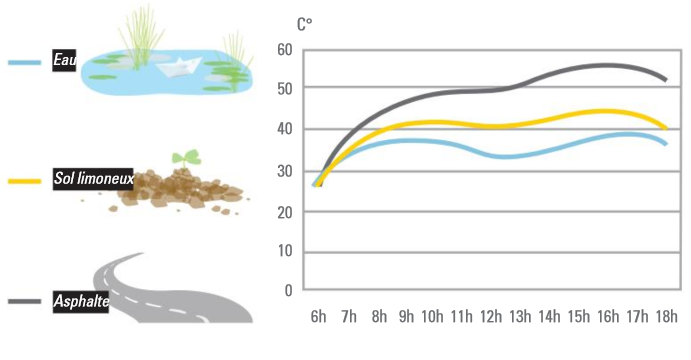
Impact of different soil types (water, silty soil, asphalt) on the radiant temperature during a typical summer day. Source: Elioth
The albedo is, for a given material, a physical quantity defining its capacity of reflecting light. At a larger spatial scale, we can define the albedo of a roof, a city or even the Earth surface. The albedo therefore depends on the form of the urban fabric, the materials, the zenith angle of the sun and is defined, similarly than for a material, as the ratio between the reflected and the incident solar flux. We then call it effective albedo.
However, many other factors contribute to the UHI phenomenon and we cannot limit ourselves to materiality and albedo, as we would then forget part of the problem and therefore part of the solutions.
Winds, for example, help dissipate heat from surfaces by convection and are therefore an important factor in regulating urban temperature, as well as human comfort. Depending on the roughness and discontinuities of the urban fabric, some parts of the city may be more exposed to winds than others.
Water can also help modify the humidity locally and therefore the temperature we feel. For example, let’s imagine ourselves walking during a summertime breeze near a fountain: everyone has experienced the clear improvement in comfort in such situation.
Moreover, the urban form also contributes to the phenomenon. The dense urban fabric creates “urban canyons” which prevent the heat from escaping into the atmosphere and reduce the urban albedo. That is why the sky view factor is an important indicator of the ability to dissipate heat to the atmosphere.
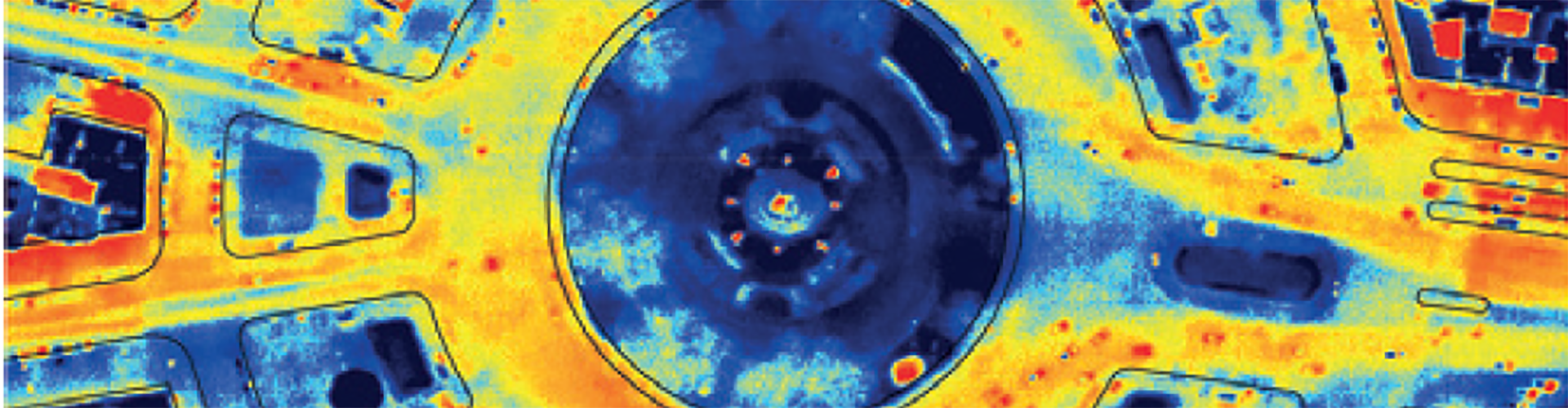
Finally, the ways we use the city are also responsible for overheating. The heat is in fact not only coming from the sun, but is also produced by human activities, such as, for example, traffic, space cooling, industrial processes, which are often concentrated in urban areas. Notice for example in the image here below the traces left by the cars heating the asphalt. Paradoxically, the use of air conditioning in indoor spaces to cope with the summer heat accentuates the problem of UHI by extracting calories from indoor to outdoor spaces.
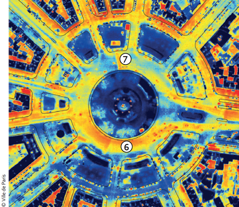
Aerial thermal photography taken on March 6, 2009 at evening : at 6, we can see that the presence of cars clearly influences the ground temperature. Source : APUR, Les îlots de chaleur urbains à Paris – Cahier n°4
The evaluation methods
We have seen how the UHI is the combination of many physical phenomena. This complexity leads to several evaluation methods being available. Their application is often determined by the scale of application (city or project area), goal (evaluation of an existing urban area or a design project) and costs. Traditionally, we rely on the measurement of the temperature difference in a urban location and a reference weather station in a rural environment. As the urban heat island is a phenomenon that is most marked during the night, we often refer to the night hours.
This measurement method allows a cost-effective (with the latest connected sensors) and precise evaluation in few specific locations for a limited period of time, but cannot be applied to the design of spaces, for which it is often necessary to compare several design scenarios with high spatial granularity for a long period of time.
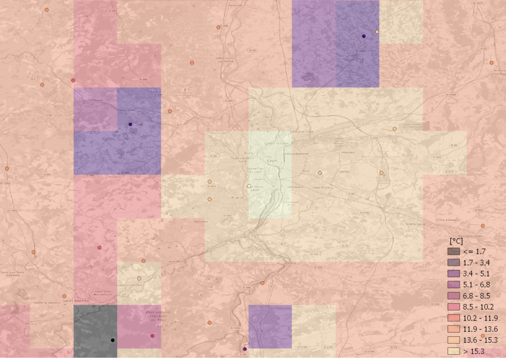
Map of the average annual temperature in 2018 for the region of Lyon (Elaboration by Elioth on data from MéteoFrance, map background from OSM). The UHI of the Lyon agglomeration is clearly visible through the data measured by MéteoFrance.
Simplified methods associating a design strategy (e.g., vegetated soil vs mineralized soil) with a coefficient of resilience to the UHI are commonly applied in practice. These coefficients are usually defined based on the color or type of materials, hence only partially taking into account the albedo. Even if these methods can sometimes be useful for comparing design scenarios, they cannot validate the actual effectiveness of a strategy against a recognized measurement scale, nor be extrapolated to different locations. The error becomes particularly important along with the increase of the site size and as the neglected parameters become preponderant. We can almost define this method as “add greenery and everything will be fine” or, to make an architectural analogy, only look at the cost of a construction and not its intrinsic qualities.
However, at a time when the computational performance should be no more a limit, at Elioth we believe that microclimatic models are the only effective method that can be applied both for a survey of an existing area and, more importantly, for verifying the effectiveness of the proposed design strategies to face UHI. Unlike simplified metrics only focusing on one or a few parameters, urban microclimate models are able to take into account (almost) all radiative exchanges in urban areas.
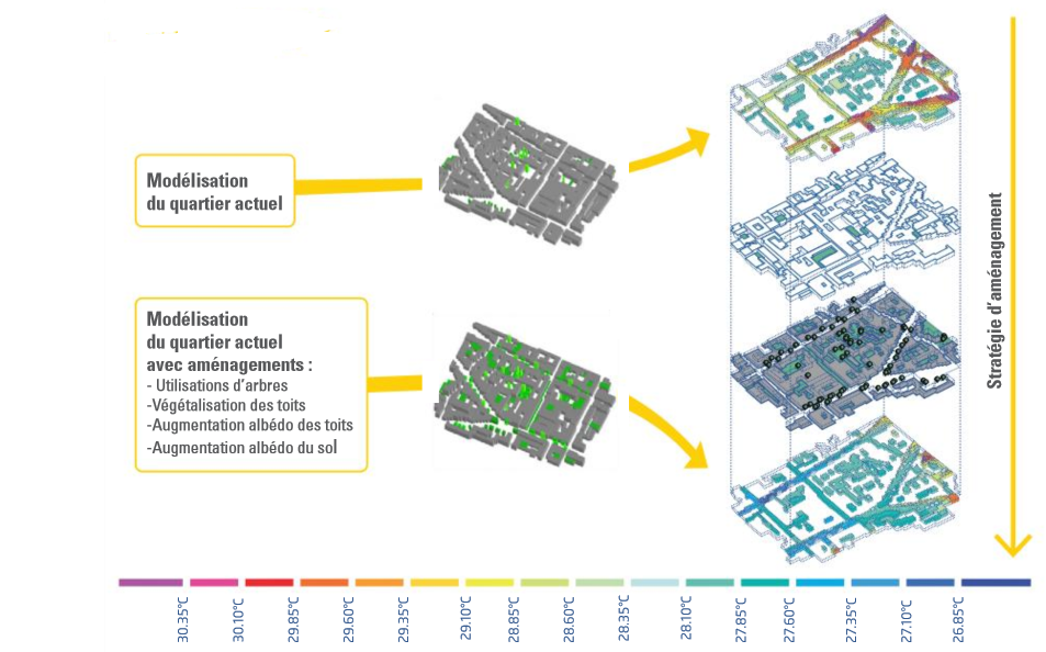
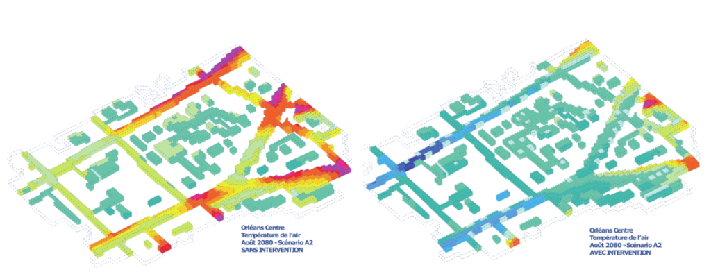
Application of microclimatic models to evaluate different planning scenarios. Source: Elioth.
Among the available microclimate models, at Elioth we commonly use software from state-of-the-art research projects, such as ENVI-Met (the only one allowing the consideration of local wind flows, normally conducted with more advanced 3D simulations), Solweig and CitySimPro. In projects for which wind is not a major issue, Elioth recommends the use of open-source models, such as Solweig.
Using this type of software also allows the integration of advanced geoinformation that is now available in many cities in Europe and around the world. These datasets are often available as open-data and combine traditional cadastral data with other information that are useful for the UHI evaluation, such as, for example, the height and characteristics of urban surfaces. Coupling microclimatic models with these datasets in a Geographic Information System (GIS) environment allows the representation of the different layers acting on the urban microclimate (vegetation, water, buildings, etc.) and the enrichment of the database with the results of the microclimatic simulations.
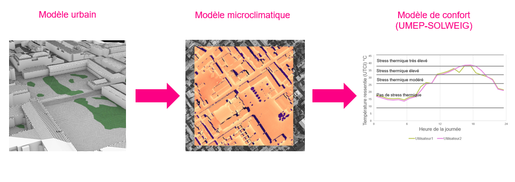
The microclimatic model can then simulate the effects of these layers on the environment, particularly in terms of temperature, solar radiation, humidity and wind speed. With these quantities, it is thus possible to integrate an outdoor comfort model, allowing the prediction of the human thermal sensation and its visualization on a map.
Feeling the project…
Thanks to such advanced urban microclimate models, it is possible to simulate both the effect of climate change and, most importantly, the thermal sensation of the users before and after the project.
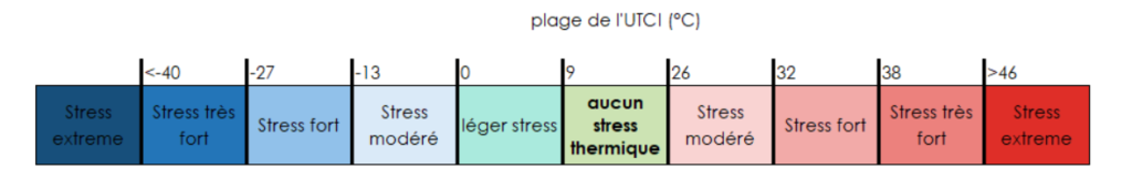
To this end, we use the apparent temperature: a virtual quantity, not directly measurable (unlike air or ground temperatures), but yet very familiar to us, as it considers the felt temperature (influenced for example by wind speed and humidity) rather than the measured one. There are several models that have been developed by researchers through experiments with users to assess their thermal sensation (e.g., it’s too cold, it’s too hot, it’s neither cold nor hot) and therefore predict the apparent temperature as a function of measurable environmental parameters. Among these indicators, we find in particular the UTCI (Universal Thermal Climate Index), an indicator that works for all temperature ranges, all climates and all seasons to predict the thermal sensation of a person walking in space.
By using such comfort indicators, we can quantify the number of hours for each thermal sensation and compare different design scenarios. We can also determine whether the project actually manages to control the risk of thermal stress, which is the first step in conceiving a resilient city.
…and making it cool
Several techniques exist to control the UHI nd help reduce overheating, at least at the local level of a project, through the creation of “oases of freshness”. Water basins, revegetation, light colors help reduce UHI and, through microclimatic models, we can assess and compare their effectiveness in limiting heat stress situations.
Elioth and its experimental architecture firm 169 Architecture also offer innovative urban furniture, which can be integrated even in heritage contexts.
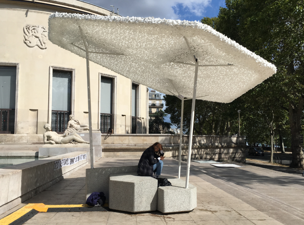
Ilot frais is an innovative urban furniture conceived by Elioth (Design by Loma Studio for Climespace) providing a refreshing oasis in the urban context
The anticipation of the UHI risk and the creation of resilient spaces is essential in the design of the city of tomorrow. The generalization of basic indicators tends to oversimplify the physics regulating the urban microclimate and prevents the use of recognized indicators of apparent temperature, which is the only way to anticipate possible thermal stress situations. State-of-the-art microclimatic models allows us to respond to these issues of well-being and public health in any urban project. There are really no excuses to start using them today.
References (in French)
Elioth. (2013). Guide d’interactions énergie_climat / Vol.2: Résilience.
APUR. (2017-2020). Les îlots de chaleur urbains à Paris – Cahiers n° 1-5.

Giuseppe PERONATO
Analyste énergie-climat

Guillaume MEUNIER
Directeur Délégué & Responsable du pôle Environnements d'Elioth